Thursday, December 15, 2011

Valdez, AK 100 Million Years in Past and Future

Humans have existed for an insignificant amount of time on the planet, and during our time here the continents have remained observably stationary; however, throughout geologic time our continents and the distribution of land masses has actually varied quite greatly. In response to these shifts in land mass, our planet undergoes a number of consequences, probably the most severe of which is climate change. As we have learned throughout class this semester, the position and arrangement of land masses greatly affects the patterns that air masses, ocean currents, and our overall climate undergo. This specific blog will focus on how these shifts change the climate of Valdez, Alaska both 100 million years in the past and future.


Valdez in the Present:
Present climograph of Valdez
Valdez's present location
Valdez in the Past:
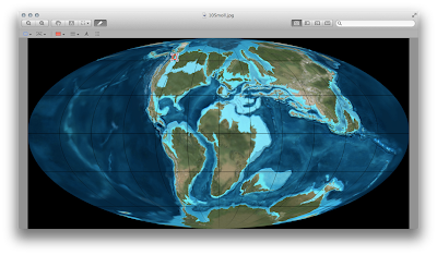
Valdez's location 100 million years in the past


Climograph of the Past


The climate of Valdez 100 million years ago must have varied greatly from where it sits today. First, the physical location of Valdez is currently 61 degrees north and 146 degrees west, but long ago Valdez was a few degrees north and east at the location 63 degrees north and 142 degrees west. The effect that the variation of physical location on the climate of Valdez is probably minimal, but there are a variety of other factors that could change the climate. Currently the Aleutian Low sits off in the Bering Sea and interacts with the polar highs coming off of the cold, large part of the continent to form enormous storms that dump record snowfall on Valdez. Well, a 100 million years ago the entire northern part of Canada and the Yukon were separated by water, lessening the continentality of the area, lowering the high pressure, and most likely preventing the Chugach mountain range from forming yet. The climatic effects on the Valdez area would be vast. The area would still see a low pressure system that sits off the coast, but the storms pushed in by the westerlies would not be as often or severe because the high pressure coming off the continent would be minimized--lessening the pressure gradient--and the Chugach mountain range would be non-existent, eliminating the orographic effects that cause record snowfall. Furthermore, Valdez would still be considered a maritime climate and would be much less effected by the continental polar and arctic air masses than by the maritime polar air masses, slightly warming temperatures in the area during the winter months. Overall, Valdez would still see dramatic storms as a result of the Aleutian Low and the polar high created by the land masses further east, but the severity of the storms, the amount of snowfall, and the wind velocities would diminish, but the temperatures would rise slightly 100 million years ago.


Valdez in the Future:

100 million years in the future


Climograph of the Future
The climate of Valdez 100 million years in the future would be much different than it was 100 million years in the past. The Aleutian Low would still be the main contributor to Valdez weather, creating storms when it interacts with high pressure to the east, but the storms would be more often and severe than 100 million years in the past because the land mass to the east would be much larger, bringing larger forces of continentality and high pressure. The physical location of Valdez would be much further southwest, probably sitting somewhere around 58 degrees north and 150 degrees west, causing minimal climate variation except for a slight warming in seasonal temperatures as shown by the climograph. The Chugach mountain range would still be a factor, having possibly even grown in size due to the collision of tectonic plates, forcing air masses upward orographically resulting in massive snowfall. One of the largest differences in the future compared to the present is the massive gulf created between Quebec and the Yukon. This gulf would attract low pressure, probably forming something like the Aleutian Low but to the East of Valdez. This semi-permanent system would put Valdez in the middle of two low pressures, which would most likely mean more frequent, violent, and precipitous storms for Valdez as a result. Valdez would still be considered a maritime climate because maritime polar air masses would be affecting the location most of the time, but continental polar and arctic air masses would influence the area more so than 100 million years in the past. Overall, Valdez would see more frequent snowfall and precipitation as a result of its unique position between two low pressure systems and the possible growth of the Chugach mountain range, but the location would remain maritime and temperatures would warm only slightly because of its shift to the south and the resulting increase of incoming solar radiation.


Sunday, December 11, 2011

Limon, Costa Rica versus Valdez, AK

Costa Rica and Valdez are climatically different in many ways. The most obvious difference can be found in their latitudinal variations, with Costa Rica sitting at 10 degrees North and Valdez at about 57 degrees North. On the Koppen-Geiger scale Costa Rica is labeled as equatorial, while Valdez is labeled as snowy. The climographs show that Costa Rica has a much less variable temperature range than does Valdez, with Costa Rica's temperatures staying between 75 and 80 degrees the entire year. Both areas sea precipitation in high amounts, but Valdez sees vast amounts of snow as a result of its high latitude, proximity to the Chugach mountain range, the Aleutian Low, and polar air masses, while Costa Rica sees much more precipitation than Valdez in the form of rain due to the maritime tropical air masses. As is obvious by the climographs, Costa Rica sees a significant amount more precipitation than Valdez, especially in July, where Valdez sees one of its driest months and Costa Rica sees its wettest month. The equatorial climate of Costa Rica is subject to maritime tropical air masses that are rich with moisture and humidity, exposing Costa Rica to severe hurricane risk, whereas Valdez does not see hurricanes, just large mid-lattitude cyclones. Both areas are affected by some sort of low pressure system, as Valdez sits next to the Aleutian Low and Costa Rica is affected by the ITCZ--a low pressure system created by the meeting of trade winds that moves north in the summer to affect Costa Rica. The ITCZ, and the Aleutian Low, can drop tremendous amounts of precipitation in both Valdez and Costa Rica.


Sources: http://climate.gi.alaska.edu/climate/Climographs/VDZ.html
http://www.world-climates.com/city-climate-limon-costa-rica-north-america/


Both areas are affected by some sort of low pressure system, as Valdez sits next to the Aleutian Low and Costa Rica is affected by the ITCZ--a low pressure system created by the meeting of trade winds that moves north in the summer to affect Costa Rica. The ITCZ, and the Aleutian Low, can drop tremendous amounts of precipitation in both Valdez and Costa Rica.

Source: http://en.wikipedia.org/wiki/File:ITCZ_january-july.png

Thursday, December 1, 2011

The Meso and Micro Scale Climate of Valdez, AK

Of the four mesoscale influences listed in the class lecture, Valdez Alaska experiences all of them: orographic, water, atmospheric circulation, and air mass influences. As mentioned in previous blog posts, Valdez is nestled between the Chugach mountain range and the William Sound of the Pacific Ocean. The Chugach mountain range has significant orographic influences on the city of Valdez, forcing air masses from sea level to over six thousand feet--giving birth to monumental snowfall from moist air masses blowing in from the Aleutian Low and Bering Sea. The William Sound and the Pacific Ocean also influence the mesoscale climate of Valdez. Because water heats up and cools down faster than land, Valdez experiences a more moderate temperature range than other towns in Alaska as more energy goes into the latent heat flux and not the sensible heat flux. The Aleutian Low that sits to the west of Valdez in the Bering Sea also has a tremendous effect on Valdez's climate. Especially during the winter months, the high pressure that is initiated by the cold, heavy air of inner Alaska and the northern arctic creates a pressure gradient with the Aleutian Low to form enormous storms. Finally, the air masses that affect the mesoclimate of Valdez include the maritime polar, continental arctic and continental polar air masses. In the winter months, the continental arctic and polar air masses influence the area more, whereas the maritime polar air masses influence Valdez more in the summertime.

Source: http://minnesota.publicradio.org/collections/special/columns/updraft/archive/2010/02/forecast_last_arctic_blast_of.shtml

In addition to mesoscale climatic effects, there are also numerous microscale influences on Valdez. Valdez sits at the base of a river valley that extends up into the Chugach. This has several effects on the microclimate, including windy conditions and cold air ponding. Cold air hugs the lowest elevations, and the river valley funnels the cold air from the mountains down into Valdez, but it also funnels wind from the high pressure gradient forces that Alaska is known for. As for anthropogenic effects on Valdez's climate, there are few because people are sparse and the environment as a whole is effected very little by the activities of Valdez. To my knowledge, there are no invasive species issues, smog, irrigation, or other anthropogenic influences in the are.


Aerial view of Valdez, AK sitting between the Chugach and William Sound
http://www.alaska-in-pictures.com/port-of-valdez-aerial-3068-pictures.htm

The Koppen Geiger scale classifies Valdez as a DFC, where they experience a snowy climate, very humid conditions, and a cool summer, which accurately depicts the climate of Valdez according to my observations.

Aerial photo of Valdez Airport where the weather station I am using is located
http://www.airphotona.com/image.asp?imageid=12109

It is difficult to get annual precipitation data from the weather stations in and around Valdez; only one of the four stations had precipitation data. Of the data that I could find, the year of 2011 has been very dry in Valdez with only 21 inches of precipitation, whereas 08', 09', 10' saw 37 inches, 42 inches, and 33 inches respectively. There is still one month left in the year for Valdez to make up some ground, but historically they don't see much precipitation in December. In reference to temperature, I did have access to temperature data dating back to the 70's; however, there was no consistent pattern of temperature swings that I could determine from the monthly data that was available.

Source: http://www.wunderground.com/weatherstation/WXDailyHistory.asp?ID=MRHVA2&graphspan=year&month=12&day=1&year=2011

Thursday, November 10, 2011

Valdez, AK vs. Los Angeles, CA

Los Angeles, being much further south in latitude than Valdez, can be expected to have a much different climate. LA is located in southern California, where it is affected by maritime weather patterns, both polar and tropical, as well as the rare continental tropical air mass, which keep the annual temperatures relatively moderate for the majority of the time. Valdez and LA share the maritime location in common with each other, but other than that they are very dissimilar. LA experiences a thick layer of fog that develops over the city between the mountain range to the east, and LA also experiences a large inversion layer that traps the emissions from the second largest city in the US, causing the smog that LA is notorious for. Valdez does not have the inversion issue that LA does, but being tucked between large mountains and the sea, Valdez experience cold air pooling and occasional inversions. Both cities have mountain ranges to the east of them, but the effects of the mountain range on each city differs greatly. LA experiences a phenomenon known as the Santa Anna Winds, a warm easterly wind pattern created from a pressure gradient between the cold, high pressure areas between the Sierras and the Rockies, and the low pressure created by the more tropical climate of LA. One of the more obvious differences between the cities is that Valdez, due to the Chugach mountain range to the east, the high latitude, and its proximity to the Aleutian Low, sees record snowfall whereas LA will pretty much never experience white fluff on the ground.


Source: http://www.google.com/imgres?q=LA+smog&hl=en&safe=off&client=safari&rls=en&biw=1045&bih=656&tbm=isch&tbnid=hsndkcxvqnQ8QM:&imgrefurl=http://www.huffingtonpost.com/2009/07/10/la-vows-to-be-coalfree-by_n_229832.html&docid=az1GbgTeA_YreM&imgurl=http://i.huffpost.com/gen/92036/thumbs/s-LA-SMOG-large.jpg&w=260&h=190&ei=HC28TpvmPMSXiAL0p6n9BA&zoom=1&iact=hc&vpx=806&vpy=346&dur=542&hovh=152&hovw=208&tx=113&ty=103&sig=115770540908780714939&page=1&tbnh=134&tbnw=181&start=0&ndsp=15&ved=1t:429,r:9,s:0

This is an image of the LA smog forming a brown cloud looming over the city


Source: http://en.wikipedia.org/wiki/Valdez,_Alaska

This is an image showing the proximity of Valdez to the Chugach mountain range, a factor that significantly influences Valdez's weather patterns and sets it apart from the weather of LA.

Tuesday, November 1, 2011

How Weather Effects Valdez, AK

Considering Valdez's extreme northern latitude nearly 60 degrees North, the people that live in Valdez experience a low average range of temperatures and drastic changes in sunlight from season to season. Though, Valdez is a port city that is very much influenced by the maritime conditions of the ocean, causing less variable weather than the inland areas. Below are charts of the annual temperature, precipitation, and daylight variances throughout the year.

US70275005096861.png
Source: http://www.climate-charts.com/Locations/u/US70275005096861.php

Valdez, and Alaska as a whole, is greatly effected by the Aleutian Low that forms in the Bering Sea, and between the months of October and April this attracts hurricane-like, wet, windy storms that blow eastward from the ocean over Valdez. As the storms pass over Valdez, they are forced up and over the Chugach Mountain Range, about 5000 feet above sea level, which forces further precipitation out of the storm system. This explains why Valdez receives about 320 inches of snow annually while Fairbanks, further inland, sees only 68. Below is an image of the Aleutian Low:
slpavgpre.gif


snow-plough-clears-storm_4343.jpg
Source: http://www.alaska-in-pictures.com/snow-plough-clears-storm-4343-pictures.htm

A snowplow clearing the roads of Valdez, showing the effects of the Aleutian Low on the snowiest place on earth! The largest snowfall on record in Valdez from one storm happened in 2009, where they saw 5 feet 8 inches of snow. The snow ended up sinking a boat due to the heavy weight, and forced other boat owners to defend their boats from the storm with shovels.

Saturday, October 15, 2011

General Information on Valdez, AK

Valdez, Alaska: Valdez is an interesting place to monitor weather from, considering it's extreme northern latitude and exposure to the Polar jetstream. Valdez is nestled between the Pacific Ocean and the Chugach Mountain Range, and is recognized for it's world-class skiing close by, record amounts of snowfall (47 feet in 1989/1990), and quality fishing both in the ocean and rivers that surround the city. Valdez is also known for the second-largest oil spill in American history caused by the Exxon Valdez in 1989--coincidentally the same year they received a record of 47 feet of snow, and Valdez has also experienced one of the two largest earthquakes ever recorded at a measurement of 9.2. The city is home to only 4,100 residents, but has all the amenities of a slightly larger town due to the large influx of fisherman and snow-lovers brought in through tourism.

Valdez Weather Overview:

Here is a chart showing the average and record temperatures per month:
weatherChart.gif
Chart: Valdez Convention and Visitors Bureau

Valdez has relatively moderate temperatures in comparison to the areas further inland, because the ocean absorbs most of the insolation in order to supply the latent heat flux, a less extreme fluctuation in temperature is experienced in comparison to its inland neighbors of the same latitude. September and October see the most precipitation, while May and June are the driest with average temperatures ranging from about 20 degrees F in January to 55 degrees F in July.